Geographical Features
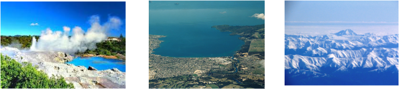
Rotorua Geothermal
- There are 5 different Geothermal Areas which all have Geysers, Hot Springs, Boiling mud pools, and Craters that can be seen up close.
- It was created by the area's volcanic activity over 1000's of years. It is described as "natures own art form"
- It is one of the finest Geothermal areas in The World.
Lake Taupo
- It has an area of 616 square kilometers making it the largest lake by surface area in New Zealand.
- The Lake was created by a 'super-volcanic' eruption and the volcano is still considered dormant.
- A ten meter high carving has been carved in a cliff in the Lake and can be accessible by boat or kayak.
Southern Alps
- They run 450 km North to South across the South Island with it's tallest point being at 3754 ft with 16 othe rpoints exceeding 3000 meters in height.
- They always have ice and snow at the tallest points of the Alps. All year round.
- It is part of the Pacific Ring of Fire.
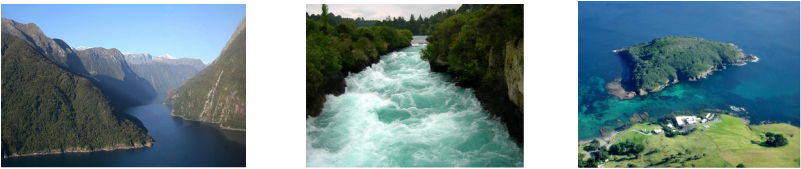
Milford Sound
- Milford Sound runs 15 kilometers inland from the Tasman Sea.
- Lots of temporary Waterfalls can be seen after heavy rainfall.
- It is about 4 hours drive from Invercargill or Queenstown.
Huka Falls
- It is Waikatos longest river measuring at 425 km.
- It is considered a great natural wonder of the world and it is the most visited natural attraction in New Zealand.
- There are also several viewing platforms that you can look at the falls from over a 30 minute walk.
Goat Island
- It is a world renowned marine reserve.
- It is 80 km north of Auckland.
- It was originally called Cape Rodney and it was the first marine reserve in New Zealand.
Rotorua Geothermal, Lake Taupo and the Southern Alps
Milford Sound, Huka Falls and Goat Island
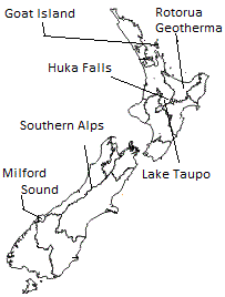
This is where all the geographical features are on a map. - Rotorua Geothermal, Lake Taupo, Southern Alps, Milford Sound, Huka Falls and Goat Island.
